Skip to main content
Code 581 Technologies and Products
Sensor Web 3G for Earth Science Decadal Missions
Principal Investigator (PI)
Description and Objectives
- Dramatically improve the accessibility, the utilization and the integration of a wide variety of sensors to measure climate change and aid in disaster management by enabling users to rapidly design and run customized algorithms onboard.
- Demonstrate an open toolset (based upon the award winning SensorWeb 2.0) to provide decision makers and scientists easy access to satellite data via visual tools (built upon Open Geospatial Consortium (OGC) standards), integrated and further enhanced using a Resource Oriented Architecture approach; SensorWeb 3G indicates 3rd generation maturity.
- Apply SensorWeb 3G to HyspIRI Visible Short Wave InfraRed (VSWIR) Imaging Spectrometer and multispectral Thermal InfraRed (TIR) Scanner instruments; the instruments share a heritage with the EO-1 Hyperion and ASTER.
- Provide added value to these missions at an incremental cost.
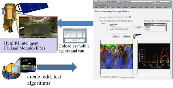
Vision: enable users to rapidly design, edit, test and run customized algorithms onboard spacecraft with Web 2.0 tools
Technical Approach
- Define science requirements & architecture for simulator and software architecture to build dynamic classifiers.
- Implement HyspIRI Low Fidelity Simulator.
- Develop the Web Coverage Processing Service (WCPS) Workflow to gather data from existing assets (EO-1, ASTER...).
- Task HyspIRI sensors through OGC Sensor Planning Service (SPS).
- Integrate classifier toolbox, spectral library and low level components.
- Demonstrate successful detection of themes (fires, algal bloom...); one demonstration per year is planned.
Main Innovation(s)
- Makes use of Open Geospatial Consortium (OGC) Sensor Web Enablement (SWE) suite of standards to interoperate space-based, airborne and ground sensors.
- Completed Fire SensorWeb pilot (2007 & 2008), two SensorWeb data simulations in Australia (floods and fires, 2009), and Namibian Flood SensorWeb Pilot project under auspices of the Committee on Earth Observation Satellites (CEOS) and the United Nations Platform for Space-based information for Disaster Management and Emergency Response (UN-SPIDER), 2009-2013.
Infusion Potential
- Most Earth Science Decadal Survey Missions
- Applications Program (Disaster Management)